

Modern state-of-the art photogrammetry software and hardware are used for producing digital topographic mapping data (planimetric features, topographic features, digital terrain model data and contours) for use in engineering, planning, site development, natural resources design/planning projects and developing base layers for geographic and land information systems. We have prepared photogrammetric base mapping using a wide range of photo scales and flight altitudes, depending upon the final map scale and accuracy required.
Typically, aerial mapping accuracies are within the range for ASPRS and Map Accuracy Standards for 1' contour accuracies (engineering applications) to 10' contour accuracies (natural resources applications) using photography from conventional fixed wing aircraft. Special flight layout considerations can be utilized for fixed wing photography to attain vertical accuracies approaching 0.1' root mean square error for special applications. For best engineering accuracies, DTM data and topographic mapping data can meet vertical accuracies as low as +/- 0.05' using low altitude helicopter based photography. We support virtually all major CAD and GIS software systems.


Orthophoto maps provide a true scale aerial photograph and can be used to obtain accurate area measurements for wetland delineation studies, impervious area analyses and similar applications. Digital mapping techniques can be used to economically produce orthophoto maps from existing or new digital elevation data. Orthophotos can be provided in a printed form or in digital form as a backdrop for GIS or CAD line maps.
Orthophotography can be provided in true color, black and white or near infrared. All imagery is seamlessly mosaiced for high quality imagery suitable for incorporation into a GIS. Pixel resolutions range from 0.15' pixel for engineering applications to 1 meter pixels for natural resources and planning applications.

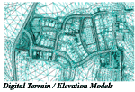
Photogrammetric mapping methods often provide an economical means of attaining terrain models and cross sections. Terrain model data can then be used for road design, hydraulic modeling or to compute the volume of topographic ground features. For volume work, aerial photography can be taken at different time intervals and used to track quantities and rates of fill and removal. Our staff is experienced in using digital elevation data and earthwork computation software to prepare cross sections, digital terrain models and to compute volume and earthwork quantities for a wide variety of engineering applications. Past projects include flood study mapping, road design cross sections, reservoir storage volume computations, landfill capacity tracking, and gravel stockpile volume assessments.

LiDAR technologies allow direct measurement of ground elevations by use of a precision laser range finder mounted in the airplane. LiDAR technologies can provide a cost effective solution for attaining 2' contour accuracy or better digital elevation model data over very large areas. LiDAR technologies also allow better penetration of the canopy in forested areas and can be of benefit for attaining digital elevation data in obscured areas where the ground is not visible using conventional aerial photography for photogrammetric mapping.
By combining LiDAR data with stereo-photogrammetry technologies using aerial photography, detailed break line data can be integrated into the LiDAR elevation model to provide a detailed terrain model that more accurately depicts terrain breaks and key terrain features. This application takes advantage of the ability of the laser to penetrate vegetation and attain extensive amounts of data over large areas while still allowing an operator to precisely locate 3D break lines or features where horizontal location is critical to the final application of the data.

Our staff can provide special consulting and arrange for integrating other services into broader projects. Some of these services include GIS applications, airborne GPS, LiDAR data collection, ground survey, hardware and software requirements and other civil, geotechnical and environmental engineering services.


 Back to top