Sample Projects
Click images for larger view |
 |
 |
 |
 |
|
|
Typical Projects
City of Olympia, WA - GIS Base Mapping 1"=100', 2' Contour Interval (C.I.) digital base maps have been prepared for the entire City. Additional projects are completed annually for mapping updates, site specific engineering design accuracy mapping, photo enlargements, and special applications.
Thurston County, WA - County Wide DTM's and Digital Orthophotos DTM (Digital Terrain Model) data, ARC/INFO 2' contour coverages, black and white digital orthophotos and color digital orthophoto updates of the entire county.
Interstate 82 Intertie - DTM's, 1' Contours and Color Digital Orthophotos DTM data, 1' interval contours, and color digital orthophotos for engineering design of this highway project in Benton County Washington. Project was done to Washington DOT specifications for a private engineering firm.
Oregon Department of Transportation Survey Accuracy Helicopter Mapping Low altitude helicopter based photography and survey accuracy (+/- 0.015 meter) centerline and edge of road profiles for I-5 through Portland and Salem.
City of Vancouver, WA - GIS Base Mapping and Updates Digital map files in AutoCAD format were prepared at 1"=100' with 2' contours over 284 1/4 sections. Initial mapping completed in 1987. Update mapping has been completed in 1990, 1995, & 1999. 1995 updates included batch conversion of existing NAD 27 files to NAD 83.
City of Medford, OR - Base Mapping and Digital Orthophotos 1:1000 metric scale, 0.5 meter contour accuracy DTM data, 0.5 meter contours, planimetric, and orthophoto mapping of the UGB. AutoCAD and ArcView Shape Files were provided. Data was mapped in metric units for compatibility with ODOT requirements and has also been converted and provided international feet for planning use.
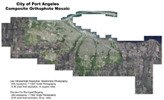
City of Port Angeles, WA - GIS Base Mapping GPS Control and 1"=100', 2' C.I. GIS Base Mapping was prepared in AutoCAD format in two budget phases.
Jackson County, OR Air-borne GPS Control, DTM Data, Digital Orthos ARC/INFO coverages for roads, water features and building outlines; 10' contour accuracy DTM data for undeveloped areas; Class II 5' contour DTM data and 5' contours for urban sections; and seamlessly mosaiced color digital orthophotos at 1' pixel resolution for urban areas and 2' pixel resolution for rural/forest land.
US Army Corps of Engineers, Colorado Site GIS Base Mapping Utilized LIDAR DEM's provided by prime contractor to develop 1.0' pixel color digital orthophotos for approximately 500 sections at two different sites to be used as GIS base mapping for USACE site evaluations and operations.

- Tacoma Public Utilities - Hydroelectric Facilities Mapping & Orthophotos
- Soosette Creek Digital Orthophotos & AutoCAD Mapping
- Portland Water Bureau, Color Digital Orthophotos
- Corps of Engineers, Columbia River Digital Orthophotos
- Northwest Natural Gas, LIDAR data integration and Mist Pipeline Color Digital Orthophotos
- Bureau of Reclamation - DTM and Digital Mapping
- Eugene Water & Electric Board - Digital Site Mapping
- PacifiCorps Digital Orthophotos, DTM's and Profiles
- Portland District Corps of Engineers - Flood Studies in OR, WA
- NRCS - Sweet Grass County, MT
- St. Johns Landfill - Digital Mapping / Volume Calculations
- Seattle, WA Corps of Engineers - Topographic Site Mapping
- Underground Cable Route Mapping - OR, WA, ID, MT
- Oregon Dept. of Transportation - DTM's for Highway Projects
- Walla Walla Corps of Engineers, Support Mapping
- Washington Dept. of Transportation - DTM's for Highway Projects
- Jackson County Roads Department, OR - Highway Design Orthophotos and DTM Data
- Tri Met Westside Light Rail Design Base Maps

